GPS Systems for

Signal distribution

+49 (0)89 99 01 63 80

E-Mail: info@aucon.de

Hohenlindener Str. 1

81677 München

Aktuelle Nachrichten

Autem vel eum iriure dolor in hendrerit in vulputate velit esse molestie consequat, vel illum dolore eu feugiat nulla facilisis at vero eros et dolore feugait.

Category Archive news-en

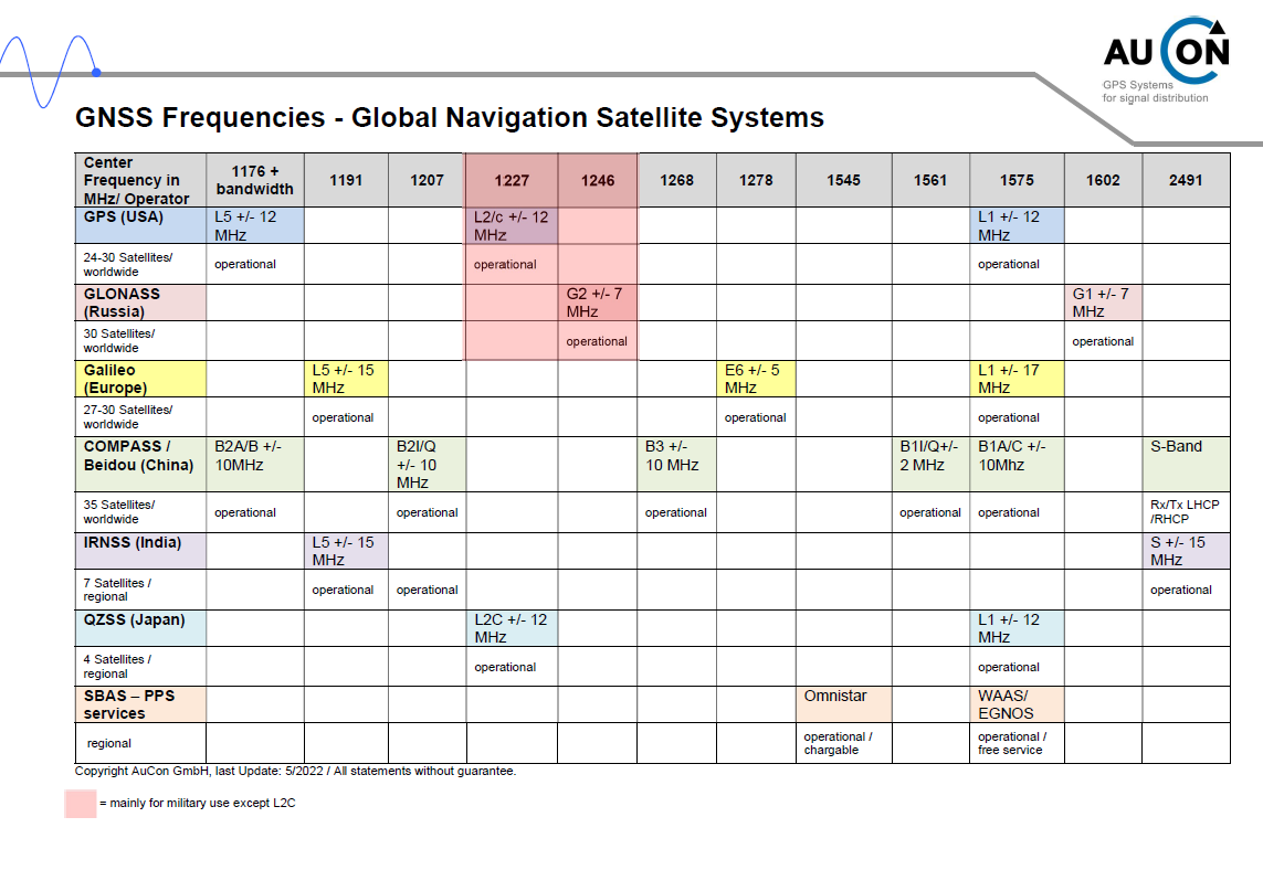
Frequencies of the GNSS

Frequencies GNSS

GPS frequencies

The data signal, with a bit rate of 50 bit/s and a frame period of 30 s, is being transmitted on two frequencies at the same time, using a spread spectrum method:

L1 (1575 MHz)

The C/A code for civil use and the not poblicly known P/Y code for military use are being deployed on this frequency. The transmitted data signal is identical on both code sequences and constitues the 1500 bit long navigation message. The message needs half a minute to be transmitted and contains every important information on the satelite, such as date, identification number, corrections, orbit, but also the condition of the satelite. GPS receivers normally buffer these data. For the device initialisation, also the almanac data, which contain the rough orbiting data of all stelites, are being transmitted. The transmission takes about 12 minutes.

L2 (1227 MHz)

The second frequency transmits the P/Y code only. This frequency may solely be used for military purposes. By transmitting on two frequencies, the data accuracy can be improved.

L5 (1176 MHz)

This new frequency is supposed to further increase the stability of the reception and is intended for aviation and rescue service applications. It is still under construction.
 

GNSS

meaning Global Navigation Satellite System, is a system for positioning and navigation on earth and in the air by receiving signals from navigation satellites and pseudelites.

GNSS is a collective term for existing and future satellite systems:

  • GPS (Global Positioning System) – USA
    fully functioning since 1995
  • GLONASS (GLObal Navigation Satellite System) – Russia
    not fully functioning as of today
  • Galileo – Europe
    completion expected around 2020
  • IRNSS (Indian Regional Navigation System) – India
    functioning since 2016
  • Beidou (Chinese for the Big Dipper asterism)
    completion expected around 2020
  • QZSS (Quasi-Zenith Satellite System) – Japan
    completion expected around 2020
  • SBAS (Satellite Based Augmentation Systems)
    Are satellite based supplement systems, that support existing other satellite navigation systems.

More information: here.

Die verschiedenen Satelittensysteme verwenden unterschiedliche Frequenzen:

Frequencies of the GNSS

The different satellite systems use different frequencies:

Navstar GPS

The Navigational Satellite Timing and Ranging – Global Positioning System is the US-American satellite System. It was built up in the 70’s by the U.S. Department of Defense for military purposes and has been fully functioning since the mid 90’s. Read more about the frequency bands L1 (civil), L2 (military), L2C, L5 (under construction) and L6 here.
Link zu News Eintrag GPS frequencies

Glonass

is a satellite navigation system run by the Ministry of Defence of the Russian Federation. The buildup and the mode of functioning resemble the US-American NAVSTAR GPS. The two comparable systems were developed independently from one another at about the same time during the Cold War for military reasons. the Glonass development started in 1972 and was completed in 1996.

Galileo

is the european satellite navigation system, mainly for civil purposes. It is supposed to revolutionise the by now outdated GPS system and to prevent the EU’s dependency.

IRNSS

The Indian Regional Navigation Satellite System is a scheduled Indian system for satellite navigation, similar to the existing GPS, Glonass and the foreseen Galileo systems.

Beidou

is the navigation system of the People’s Republic of China. It has been in operation since 2004, however, the use is limited to the Asian area. As China is also involved in the European system Galileo, it is not yet clear, whether it will be fully completed.

QZSS

The Quasi-Zenith Satellite System is the Japanese satellite system, still under construction, which is supposed to complement the global navigation satellite systems. The stellite constellation consisting of 3 geosynchronous satellites was especially designed for Japan, but also other areas of the Asian-Pacific region will benefit from it.

OmniSTAR (satellite-based augmentation system)

is the worldmarket leader when it comes to transmitting DGNSS correction signals via satellite and is part of the Fugro Group, a globally operating service and consulting company. The OmniSTAR services were specifically designed to cover the need for exact positioning systems and the corresponding services for land-based applications.

Galilleo is waiting in the wings

22 satellites are already in space and 4 more will follow by the end of 2018. Galileo will be fully functioning then.

Advantages of Galileo

  • Increases the EU’s independency
  • Stable system
  • Signal authentification
  • Quicker TTFF (Time to first fix)

(Source: The operator’s presentation at the MSNS 2018)


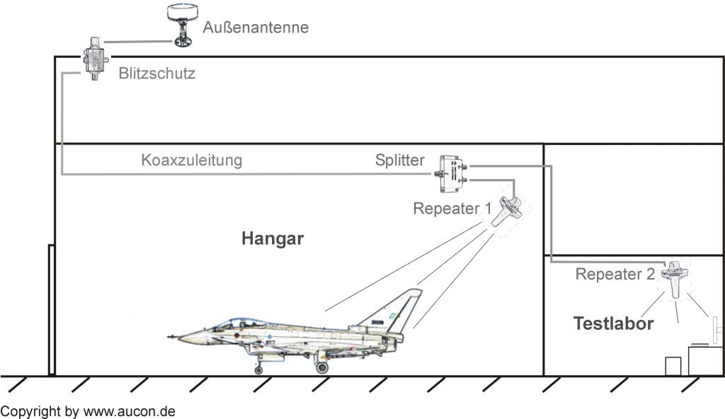
Set-up of a GPS repeater unit

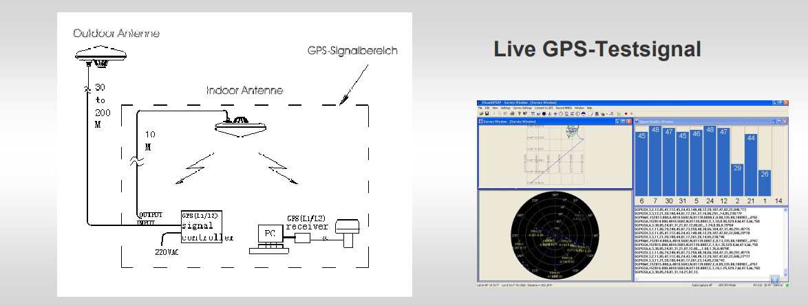
A high-performance outdoor antenna (e.g. on the roof of your building) receives the GPS signal and redirects it to one or more repeaters via special low-daming HF cables and GNSS splitters. The amplified signals are then being conditioned and radiated into e.g. a hangar or a test laboratory, via GPS transmitting antennas.


Certified partner of the German armed forces

The Federal Office of the Bundeswehr for Information Management and Information Technology has granted us the general permission to set up GPS repeaters on Bundeswehr premises. As a certified partner, we supervise the installation of components, issue installation records based on the ETSI standard EN 302 645 and grant help with all required formalities. If existing GPS systems need to be expanded, we gladly provide you with information in the current procedural method.

Certification (only in german) PDF

GPS retransmission systems for long tunnels

GNNS retransmission system

The problem getting lost of the gps signal is growing, as a lot of mobile machines (cars, trucks, construction machines etc.) and persons are tracked by GPS.

More and more vehicles require GPS signals, however, there ary many situations, in which no GPS reception is available, e.g. in tunnel systems.

Together with our partner GPS source, AuCon has developed a solution to redirect the natural GPS signal into a tunnel. A transmission via coaxial cable would be too costly and the signal transmission would be too delayed for the terminal devices to work exsctly. The new system is based on an innovative kind of transmission with an automatic regulator and a special optic fibre, to redirect GPS signals over a long distance without a time lag.

Further information: GNNS Retransmission System

GPS test system for R&D and QM

GPS test system for R&D and QM

  • Quick generation of real signals for GPS, Glonass and Galileo
  • Static and dynamic scenarios, intergrating effects
  • An embedded smart amplifier provides for a safe level control
  • Ideally suited for tests on GPS receivers
  • Suited for stationary and/or mobile use
  • On-site service and support with your projects

Find more information in this information sheet

Military GPs solultions

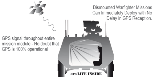
As partner of GPS Source/USA, we offer complete repeater systems, specified according to MIL standards, suited for varius military purposes, which ensure a continuous and flawless GPS reception in e.g. halls/buildings, aircrafts or vehicles of all kind. This provides for an instant readiness of the navigation system, e.g. at quick-response starts of airplanes. Also for troop transports, a steady GPS reception is very important, especially in the scope of equipment renewal for the infantry (IdZ – ES, or NATO Soldier Modernization for other NATO partners), as it supplies the soldiers with instant orientation when jumping off transport or combat vehicles auch as the Boxer, Dingo or Puma. The oftentimes lengthy acquisioning process for a valid GPS signal (L1/L27L5) can be omitted, the GPS signal is instantly available. Same applies for parachutists with NavAid Receivers, who jump off transport planes. Several Boeing C-17 Globemaster machines have been successfully equipped with this specially adapted system. For the Airbus A400M, a kit is already being tested.
The main advantages are:

  •  Eliminates the often lengthy acquisioning process for a valid GPS signal (Time To First Fix- TTFF)
  • Exact knowledge of the position at any time, especially during transport or on jump-off
  • Continuous availability of valid positioning data, e.g. for radio, locating and navigation
  • Repeatedly battle-tested technology
  • Longer operating times of GPS handhelds due to lower power imput during tracking

Download pdf-file GPS-Repeater for armoured vehicles/ Eurosatory 2010(900 kB)
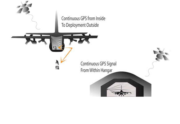


Together with our US-American partner GPS Source, ione of the biggest producers for GPS signal distribution, we develop, adapt and integrate GPS repeater solutions for branch- and customer-specific GPS applications both for military and civil use.

For over 10 years, AuCon has been focussing on GPS systems for signal distribution to optimise process flows in production halls, workshops and laboratories. In the fields of civil and military aviation, the reception of GPS signals in hangars or workshops can contribute to substantial cost savings and additional safety. The avionics can be easily tested inside the hangar, without having to move the aircraft outside the hall. Just recently AuCon won the tender to equip all aircraft shelters at the NATO airfield in Neuburg/Donau and is thus contributing to fighter jets such as the Eurofighter and the Tornado being able to take off in navigation mode more quickly, due to a constant GPS reception.

If you require a valid LIVE GPS signal in a vehicle or a hall, please contact us for more information.

Your personal contact for MIL applications:

Mr. Willi Fink
E-Mail: vertrieb@aucon.de

See a pattern for a signal distribution in a hangar(400 kB)


AuCon references at Bundeswehr:
JG 74 Neuburg, JaboG 31 Nörvenich, JG71 Richthofen, Heeresflugplatz Rheine-Bentlage, Fliegerhorst Faßberg, Fliegerhorst Jagel, Flugplatz Niederstetten, Görmarkaserne, TU Freyung u.v.a.


Press reports:
Wehrtechnik 2010, MIL-Tech, Strategie & Technik, German Army Armament 2010, Wehrtechnik 2012


AuCon references in the field of security and defence:
RUAG, Cassidian, Eurocopter, EADS Defence & Security, EADS Military  Air  Systems, Krauss-Maffei-Wegmann, Rheinmetall Defence and more

In some cases, we can give you more detailed information on reference projects upon personal request.

Exhibitions 2012: Eurosatory/Paris

We will offer trainings and information events on GPS simulation, GPS test engeneering and on measures against GPS jamming, GPS spoofing and GPS faking, shortly.

New products and developments in 2013: GNSS AntiJamming, phased array antennas, GPS signal generators and simulators.